

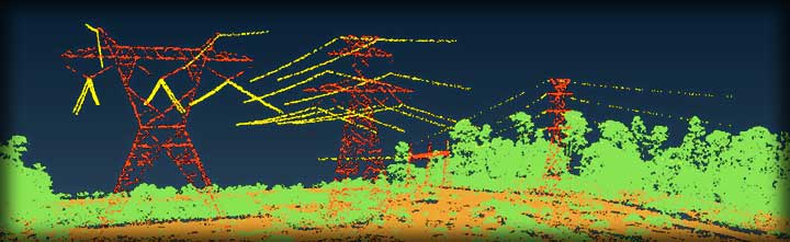
Transmission Line Survey – Minnesota
LiDAR Services, LLC, Las Vegas, Nevada, the wholly owned US subsidiary of LiDAR Services International, Calgary, Alberta, completed a major aerial LiDAR survey of 1300 miles of existing transmission lines for thermal rating and NERC compliance in north central USA for a large electrical utility. LiDAR Services teamed with a large engineering company that performed all of the PLS-CADD analysis for the project. Besides LiDAR data collection, downward digital imagery, oblique video, meteorological (MET) data, and ground based and airborne GPS data were collected and processed to meet deliverable requirements. The thermal rating analysis needs were fulfilled including the NERC FAC-008 mandate for the electric transmission company.

LiDAR Mapping – Transmission Line Demonstration:
http://www.youtube.com/watch?v=NQbol5gInec
Transmission Line Survey – Maine
LiDAR Services LLC., (LLC) a wholly owned subsidiary of LiDAR Services International Inc., (LSI), completed a NERC Alert facility rating LiDAR survey request for an electrical utility company in Maine. The project required both LiDAR and downward digital imagery data collection to meet the NERC Alert Facility Ratings for approximately 140 miles of existing transmission lines. LSI’s tasks included the deployment of GPS receivers and MET stations to support airborne LiDAR operations, processing of the LiDAR, IMU, imagery and MET data and feature coding of the LiDAR data points as per the supplied Feature Code Table. The PLS-CADD analysis was performed by an engineering company LiDAR Services LLC teamed with for the project.

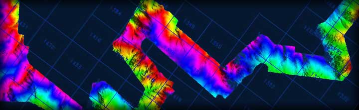
Mining – South Dakota
LiDAR Services LLC., (LLC) a wholly owned subsidiary of LiDAR Services International Inc., (LSI), completed airborne LiDAR and imagery data collection and processing services for a mining company in South Dakota for their mine concession. Deliverables included bare earth and full feature grids, contours, classified LiDAR point clouds, hill shades, imagery, index map and final project report. The airborne LiDAR and imagery provided a comprehensive, detailed and accurate data from which analysis, design and modeling would be completed allowing for better informed decisions. The LiDAR survey provided bare earth topographical data for detailed ground surface analysis without removing any vegetation from the project area.

Additional Project Locations
• Arizona • Maine • Minnesota • Montana • New Jersey • North Dakota • Vermont